|
Climbing
in the Wilderkaiser (Nordwand, Ostlerführe)
Route / Accomodations
/ Other routes / Links
/ Guidebook
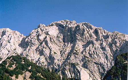
North Wall, Ostlerführe of the Scheffauer
(400m, IV, A0)
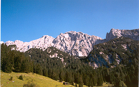
The whole Wilder Kaiser range is home to more
than 200 rock climbing routes with summits ranging between 1900
to 2400m and routes in length from 75 to 800 meter and of all
grades. The area is famous for its rock climbing and hiking
possibilities, with more than 10 huts offering meals and accommodations
in altitude. You would think that during a long weekend in August,
there would be lots of climbers on these routes (like in the
Dolomites),
but we found them to be almost devoid of humans, we met or observed
5 other climbers. There are many hikers though and a popular
Klettersteig (alpine hiking trail that involves some climbing
with metal ladders) goes right above some of the shorter, more
sports routes, and we were forced to retreat from one of these
routes due to the constant hammering of varied sized rocks coming
from the hikers above us. Protection: this is an alpine route,
there are some pitons, but not often and not always where you
would like them to be. A good number of slings and your whole
rack of protection (at the least) will be necessary. On top
of it, it is said that some people go around and hack off the
pitons in place, so definitively bring your own protection,
the pitons indicated in the book might have disappeared by the
time you arrive to the route.
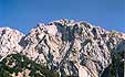
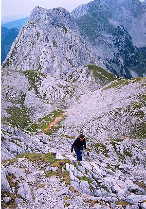
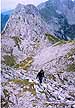
The Scheffauer |

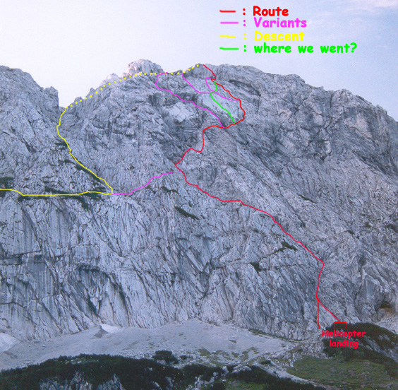
view the route on a photo |
Access:
From the Kaindelhütte
follow the path going to the Klettersteig (named: Wildauersteig),
stopping at the Grosser Friedhof, just before the first real
climbing of the Klettersteig. From the path go up towards the
Helicopter landing (a nice patch of flat grass
.). From the
Helicopter landing, as you look up the mountain, slightly to
the left is a triangular shaped promontory; you can start on
either side of it. From the Kaindelhütte count 1 hour (including
time to find the route
)
Route:
While not so short, the route is definitively not very difficult
but it is not always obvious to find
Also there sometimes
is no protection at all at the places where you are supposed
to relay.
- 1st pitch: we chose the right one, that goes along a crack,
until you are right next to the big overhanging crack. If
you come from the other side of the triangle, this is where
the 2 routes meet. 45m, III.
- 2nd pitch: Continue along the big crack, then as soon at
it is passed, on top of it either along the ridge or in the
(wide) crack next to it. (45m, III)
- 3rd pitch: back into the crack and follow it until you get
above a steeper part. Slightly to the left there is a nice
view over the whole valley. (45m, II-III)
- The 4th pitch is a long traverse. Follow the obvious path
going towards the left. You will pass 1st a narrow gully going
straight up. DO NOT go up that one, it will eventually lead
you to some hard climbing, instead, continue along the path
until you reach a wider gully going up into an even wider
hole with lots of loose rocks. Relay somewhere at the bottom
of the gully. (70-80m, I).
- 5th Pitch: continue up the big hole first straight up (30m,
III)
- 6th pitch: Continue up the gully for a short while, then
follow the "ramp" going right to the ridge. Do not go around
the ridge. (30m, I)
- 7th pitch: follow the ridge more or less straight up (45m,
III)
- 8th pitch: follow the ridge, going towards the left underneath
the smaller of the 2 slabs on the face. (30m, III).
- 9th pitch: continue traversing, to right after having passed
the overhang. (30m, III)
- 10th pitch: Continue traversing through some grassy area
until you get to a rocky ridge. Continue a bit to the end
of this ridge. (30m, I-II)
-
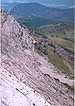 |
a view from the middle of the slab |
- 11th pitch: Start going straight up a nice crack, then slightly
to the right. To the bottom of an obvious crack traversing
slightly left on the big slab (50m, III) . (From
here on, during our climb, we might have gone a different
route than the one we describe here. After looking at our
pictures we seem to have taken an obvious crack going right
through the slab, which, looking back at the guide book, seems
to be wrong. that would explain why the end of this crack
seemed harder than a III+.)
- 12th pitch: at this point you may choose to go completely
to the left and avoid the crack, which is not the route we
chose, we therefore cannot describe it. Instead we went straight
up the crack (heading up diagonally to the left), a beautiful
45m, III+.
- 13th pitch: Follow another crack up to right below the
big final overhang. (15m, III+).
- 14th pitch: traverse under the big overhang to your right
until you get to a rock stuck in the crack. This is the crux
of the whole route. There is a piton somewhere there and possibility
to put in your own protection. Be careful, as there were more
than one piton when we did the crack, but one of the was loose
Go above the rock and follow the little chimney to the summit
of the route. (30m, IV/A0). The move is rated IV/A0, but we
both found it not so hard. My partner, seconding with a backpack
found it easier than some spots on the crack on the big slab
just below.
- Once at the top of the route, you can (and we recommend
it) follow the obvious path (Klettersteig) to the summit of
the Scheffauer to enjoy a really nice view.
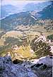
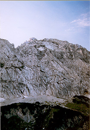
Looking down the last pitch |
The top of the path going down |
Descent:
Follow the path of the Klettersteig called Wildauersteig going
down along the big gully to the climber's left of the route.
There are metal cables and sometimes steps, but still be careful,
and make sure not to bring some rocks down as there are many
rock climbing routes directly below.
Escape route:
There is an escape route from the Ostlerführe (apparently II
and easier). We had stable weather conditions and therefore
did not need it, but it might be very helpful when the weather
changes. Especially since the whole route might take quite a
bit of time, considering that it is not always easy to find
your way. This is what the guide book recommends: From the grassy
part with lots of little stones after the 4th pitch go upwards
to your left, and then do NOT follow a steep gully up into a
big hole with lots of "pebbles" and loose rocks in it (that
would be the original route), but go to your left, most of the
time a bit downwards for 50 meters until you meet up with the
Wildauersteig.
Route / Accomodations
/ Other routes / Links
/ Guidebook
Practical information:
Accommodation: As previously
mentioned, there are many huts in the area (more than 10).
We were staying at the Kaindlhütte,
the closest hut to the route. It sleeps approximately 40 people
and the owners are friendly, have done some of the routes in
the area and will be more than happy to talk about them.
Other
huts in the area.
|
|
The view from the hut in the evening light |
To access the Kaindlhütte:
- You can go to the "Wilder
Kaiser" lift in Kufstein, go up both portions. From
the top of the lift, a 1hour hike should be enough to reach
the hut. This way is easy and nice, but, if the lift is
already closed, this means a long hike (up and down).
- We were told of another way: Drive to Scheffau and the
Hintersteiner See, park around there and it is an easy 1
hour hike from there, around the Wilder Kaiser massif.
Other routes:
As previously mentioned, in the whole Wilder Kaiser, there are
many routes, below are a few interesting ones:
- From Kaindlhütte:
There are 4 "Sport" routes that start from the area where
our route started. They are all approximately 150m in length
and some might be hard to find (we only found 2). They go
directly under the Wildauersteig and therefore are prone to
receiving falling rock from careless hikers:
- Rovereto Weg: 150m, V-.
- Sodom und Gomorrha: 175m, VI+.
- Alt und Jung: 165m, VII.
- Via Gabriella: 150m, V+.
- There are also many alpine climbs:
- The Ostwand (East wall) on the Zetterkaiser: this
route (and variations) is approx. 300m, IV+. Variations
can go up to VIII-.
- The Kaindlnadel: unfortunately we have no information
on this route, but it starts the same way as the Ostwand,
just goes up the needle to the left of the Zettenkaiser
for the last 2 pitches.
Others in the Wilder Kaiser:
- Fleischbank: (Flesh bench
.): 2187m Over 20 routes
on both sides in all difficulties This is a famous summit
of the area and host to many routes:
- Ostwand Dülfer: 360m,V/A0.
- Neue Ostwand: 360m VI/A0
- Ostwand Aquarell: 300m, VI.
- Christaturm: 2170, right next to the Fleishbank:
- SO-Kante:
270m, V/A0.
- Neue Ostwand: 220m, VI-/A0.
- Direkte Ostwand: 220m, V+/A0/A1.
Links to the area:
Guidebooks:
Kaisergebirge extrem (in german) Fall 1999.
Pit Schubert
Alpenvereinsfürer (Alpine club guide book)
Bergverlag Rother GMBH, Munich.
Route / Accomodations
/ Other routes / Links
/ Guidebook
|