|
Mountain
biking in Pisgah North Carolina.
|
| Last November, I drove down to North Carolina
from Montreal for a week of mountain biking in Pisgah National
Forest. It's a long drive but to minimize the pain I managed
to spread it out over 3 days: I left work Friday afternoon
and met my partner at his place in Saratoga, New York (3 hours from
Montreal). We did a little bar tour that night in Saratoga
(you can't pass up a night out in Saratoga), and then we left
early the next morning (okay, relatively early). 11 hours
later, we met some friends of in Chapel Hill, North
Carolina, where we went out and had a few drinks. In preparation
for our week of camping and mountain biking, we passed out
on the floor of the friends' condo that night. We got in the
car again the next morning and arrived 4 hours later at our
destination: Backcountry Outdoors in Pisgah Forest, just outside
Pisgah National Forest. |
|
 |
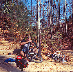
We had found out about the 'Backcountry Outdoors' store and 'Off the Beaten Track Volume II' by Jim Parham (a book you could buy at the store) from web-sites about mountain biking in the area. Off the Beaten Track was an excellent guide to many of the trails. The web-sites had also suggested where we should camp: Davidson River Campground, conveniently located 5 minutes drive from the store, but also ideally placed to serve as a base camp for our daily trail rides over the next week. So we bought the book and a topo map, put up our tent, found a good radio station (93.3, The Planet) and were finally all set for our week of biking - time for a beer. Which brings me to what was probably our only complaint about the area: bars, or rather, the lack of them. We tried and could not find a single one. We probably could have tried harder, but bars are normally not that hard to find. The closest things were restaurants with small bars where people hang out while they're waiting for a table. It would have been nice to find a good bar because it would get really cold as soon as the sun went down. Instead, we discovered the cineplex, which provided both warmth and entertainment - we saw 4 movies that week. I mentioned that it got really cold at night (there was frost on our tent every morning), but we had clear skies everyday and it would actually get hot in the sun. Since it was November, most of the leaves had fallen from the trees and the trails were often covered with them. Sometimes they were covered enough for us to get lost (of course that's not that unusual anyway). |
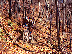
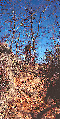
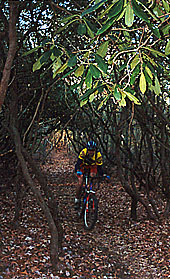
| There is a fairly extensive trail network in
Pisgah and the trails were very good in general. Most of the
trails we took were basically one long climbing section followed
by one long downhill section. The climbing section was often
on old logging roads in various states of disrepair and we
would climb for hours for over 2000 feet vertical. The trails
usually traversed up along a range until summitting or going
through a pass, rather than switchbacking straight up. The
downhill sections were mostly single-track and more direct
- fast! They had many switchbacks and waterbreaks - a chance
to get some air. Our favorite trail was Laurel Mountain, which
was a long loop with a single-track climb and a single-track
downhill and only a small road section at the end to get back
to the car. The uphill was almost all cleanable except where
trees had fallen across the trail and near the top where it
got steep. The deadfall I mentioned was usually impossible
to clean (at least for us) because the trail was almost always
traversing across a steep slope and the trees would be slanting
down the slope. In fact, the slope was sometimes steep enough
and the trail narrow enough to make me nervous about tumbling
over the edge even without any deadfall to worry about. The
downhill was excellent and very fast, with steep rocky switchbacks
and ditches to jump. |
|
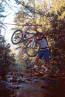 |
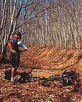
Our least favorite trail would probably have
been more popular with us in warmer weather. This trail, called
South Mills Tour, is rare for the area because it does not
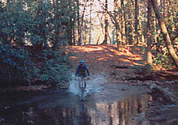
do much climbing. What it's singletrack actually does is cross
a fairly wide and deep stream over 20 times. There was one
bridge and one place you crossed using 2 cables, but otherwise
it was ride through it or try to cross over stepping on rocks
(and we tried both ways). Needless to say, our shoes and socks
got pretty wet, and our feet were frozen by the time we decided
to take a side trail. We had crossed the stream 12 times and
I think we counted 13 more to go from the map in the book.
The problem with taking a side trail is that you almost immediately
end up off the map in the book. This is where our topo map
would have come in handy. Of course, we did not have the topo
map with us since it was safe in the car. Life is more interesting
that way. When I finally saw the car that day it was one of
the most beautiful sights in the world. By that time it was
dark and we were frozen, starving, and exhausted. After dinner
we had to go see a movie to warm up. |
Apparently, November is also hunting season because
we often heard shots and we would see hunters with guns and orange
vests heading off into the woods. We tried as much as possible
to wear our brightest shorts and shirts but we often didn't feel
that safe. The biggest scare came while riding down a steep rocky
trail when I spotted a guy dressed all in camouflage hunting with
a bow and arrow. I only saw him because he moved! Good thing my
bike makes so much noise. This was an awesome trip overall, but
I would have liked to stay longer. There were many trails that
we didn't get to try and it would have been nice to do our favorites
over again. We'll have to go back, maybe a little earlier in the
season next time, and this time we'll find that bar! It's got
to be there somewhere! Note: The campground is apparently very
popular and often has no vacancy during the weekends in the summer.
Since our trip was very late in the season, however, w e had our
choice of campsites. There are also many free camp-sites along
the roads and at the start of many of the trails. These sites
have no services and may have a pit toilet if you're lucky.
-
-
-
-
Closest "city" to the park: Asheville
-
Radio Station: New Rock 93.3FM, The
Planet Modern Rock with a rough edge (perfect to wake
up before biking) Broadcasted from Greenville, SC
Bars to check out in Saratoga, NY:
-
Bailey's (ask Paul where the partying
is happening)
-
Brew Pub
-
Gaffney's Club
-
Caroline Club House (check out the bartender)
-
Desperate Annie's
-
Bullpen
-
Tin & Lint
-
Wine Bar
-
Metro Ect...
-
All within 1 block from the corner
of Caroline St & Maple Ave.
|
|
|