|
Snowboarding
in the Adirondacks, Mount Marcy
|
|
 |
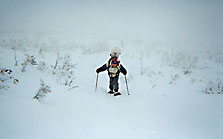
I'd heard that you could ski/snowboard/telemark
Mt. Marcy (New York state's highest peak at 5344 feet) and in fact
that you could do a lot of backcountry in the High Peaks area of
New York's Adirondack Park, but for some strange reason I could
never find any guide books or maps of the backcountry trails in
the area. Or maybe the reason isn't so strange: the less people
who know, the better the snow. Anyway, we finally decided
that we were going to go snowboarding Marcy and just figure things
out as we went along. To get a nice early start, we agreed to meet
at the crack of noon at the High Peaks Information Centre near Adirondak
Loj. The plan was to snowshoe to Marcy Dam or as near as possible
to Mt. Marcy or until we got tired, find a nice lean-to and camp
there that night. The next day, we'd snowshoe up Mt. Marcy and hope
that there was a way to board down. If there wasn't, we would simply
have taken our boards for a nice long walk. And, I'm sure we'd impress
a few hikers... Well, maybe only if they saw us hiking up. Hiking
down would not be so impressive. |
The scheduled noon meeting meant I had time in the morning to do research
for the trip. "Research" consisted in visiting the Eastern
Mountain Sports store in Lake Placid, looking in vain through all
their guide books and maps, and finally deciding to buy a topographical
map that at least showed the hiking trails of the High Peaks. That was
okay, because probably the best sources of information are the people
who work at the store. As I was paying for my map, I casually asked
the store clerk if it was possible to ski Mt. Marcy. Of course it was
possible! We pulled out the map and he showed me the trail to take,
the Van Hovenburg Trail. I was assured that there was great skiing to
be had, but he didn't stop there. In fact, it was hard to get him to
stop. He went on to tell me about five or six other great trails, which
of course I forgot soon after he had told me. Next time I'll bring a
tape recorder. My car got fresh tracks in the parking lot of the High
Peaks Information Centre so I figured that was a good sign. Another
good sign was all the people strapping on telemarks and heading out.
No snowboarders, though. Maybe we were destined to make the first snowboard
descent of Mt. Marcy - truth until proven otherwise. Before we started
out, however, we did see a couple of boarders returning from the backcountry.
But since we didn't talk to them, there was still no proof that anyone
else had boarded Marcy. Because we were going to hike up and snowboard
down the Van Hovenburg Trail, we decided that it made most sense to
camp at Marcy Dam.
|
It ended up taking us only 50 minutes to snowshoe the 2.3 miles,
so after finding a lean-to and vaguely setting up camp it was
still only 3:15 PM. On the hike in, people kept asking us where
we were planning to snowboard. In the parking lot, a bunch of
hikers had been truly amazed when we had told them that we were
going to snowboard down Marcy. According to them, Marcy was all
ice. So when people asked on the trail, we were more timid with
the Marcy response. But some were into giving us advice on alternative
trails. The most promising came from a guy who told us that he
had spoken to a couple of snowboarders who had found a great trail
down the side of Phelps Mountain. We found Phelps on the map (the
trail to the summit branches off the Van Hovenburg trail less
than a mile from Marcy Dam) and decided to see how far we could
get without pushing it so we could return before dark - the sun
would set in less than 2 hours. At this point, we made our first
mistake. We decided to travel light since we weren't going far,
and light meant no packs. That meant no snowboards, but more importantly
no headlamps, food, or water. Okay, so it wasn't the wisest decision
we've ever made. We started up Phelps and met some hikers coming
down who told us there was a skier on the top looking for a ski
trail down. A bit higher up the trail, we met the skier who had
given up looking for the ski trail. He said that supposedly you
found the trail by entering the woods off the top near an open
ridge. Also, the trail was supposed to end on the truck trail
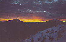
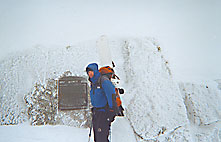
below Marcy Dam. We arrived at the top in time to get some nice
pictures of Mt. Marcy at sunset and of the sun setting behind
Mt. Algonquin.
|
 |
 |
We weren't worried about snowshoeing back down in
the dark because the hiking trail would be easy to follow. This
is when we made our second mistake. We easily found the ski trail
even though there were many dead-end trails on the top (most of
them ending in old piss-stops). The mistake: we decided to return
to Marcy Dam by the ski trail instead of the hiking trail to see
if it was worth snowboarding tomorrow instead of Marcy. The first
part of the trail was excellent. It had steep sections, good snow,
some untracked powder, nicely spaced trees. The second part of the
trail was... dark. And the real problem was that it wasn't really
a trail anymore. It seemed that everyone who had skied it had their
own way of hiking out. We ended up following a trail made by some
snowshoe-ers. It was pretty rough to be walking around in the woods,
in the dark, vaguely sensing where the trail was going, but knowing
when you stepped off the trail because the snowshoes would sink
in a little deeper. Oh yeah, and did I mention that we didn't have
any food or water? Well, at least we weren't carrying any cumbersome
packs. With relief, we finally came out of the woods onto the truck
trail and made it back to our lean-to. |
 |
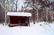
It was only 6:30PM, but the sun had set over an hour
and a half before. There were two other guys sharing our lean-to
and they were already asleep. So after heating up our dinner (Campbell's
Chunky), drinking our one and only beer each, and beginning to freeze,
we decided to go to sleep too. I think we managed to stay up until
8:30PM. The long night was uneventful except for when a black lab
decided to snuggle up next to us. I think we were both awake listening
to something moving about in the snow when the something scared
the crap out of us by jumping up into the lean-to. When we realized
that it was just a dog and that it didn't intend on leaving, we
let it stay. It even managed to force it's way onto a little of
one of our Therm-a-rest. The next day, we made our plan. We would hike
up Marcy and snowboard down, not because it was the best run but
because it was the highest and most well-known, and also because
it was what we had set out to do. Then (because we always make great
plans) we would stop at the Phelps trail junction on the way down,
hike up Phelps and then snowboard down. The second part of the plan
would depend on how much time we had and on how tired we were. |
| It's a 5.1 mile hike to the top of Mt. Marcy from
Marcy Dam, and it took us about 4.5 hours to do it. Part way up
we decided (wisely - let's not make another mistake) to leave Phelps
for another day. Most of the way, we just kept wondering how the
heck we were going to snowboard down because, except for one small
section of less than a mile where a marked ski trail branches off
then returns to the main trail, the Van Hovenburg trail is essentially
a hiking trail. It was going to be like downhill mountain biking
without brakes. And some parts are pretty steep. But on the way
up, we met groups of skiers and one snowboarder (okay, so we wouldn't
be able to claim first descent) coming down so we knew it could
be done. The wind was howling at the peak and visibility was very
low. |
 |
 |
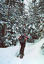
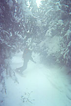
We switched snowshoes for snowboards and headed down.
The top is above tree-line and there was actually a nice, though
short, open section. We quickly ran out of open terrain and started
down the trail, trying to slow down for the corners and ducking
under dead-fall, scattering hikers as we went. The way down has
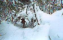
some annoying uphill sections that meant we had to unstrap the boards
- the telemarkers had a huge advantage on these sections. The wider
downhill sections were very enjoyable and the snow was good though
mostly packed down. Emergency stops were made mostly by cutting
into the woods. Helmets are a good idea. Also, packs that don't
stick out too much in back as we discovered when we cut corners
too close and the trees caught our pack and whipped us around.
We made it back to camp 6 hours after we had left it. Needless to
say, it was a very interesting ride down, and it would be awesome
on a powder day. Still, even though we didn't have ideal conditions,
the run down was still much better than hiking down. We will definitely
be back some day to try some of the other trails. Now, all that
was left was to pack up and snowshoe back to the parking lot. It
was funny how heavy the packs seemed. |
|